Moki Dugway Utah: Conquer the Scenic Switchbacks with Confidence
The Moki Dugway in Utah is more than just a road; it’s an experience. A three-mile stretch of unpaved, but graded, switchbacks carved into the face of the Cedar Mesa, the Moki Dugway offers breathtaking views and a thrilling drive. But before you set off, it’s crucial to be prepared. This comprehensive guide provides everything you need to know, from navigating the steep grades and hairpin turns to understanding the history and geology of this iconic Utah landmark. We’ll equip you with the knowledge and confidence to make your Moki Dugway adventure unforgettable.
What is the Moki Dugway? A Deep Dive into Utah’s Scenic Marvel
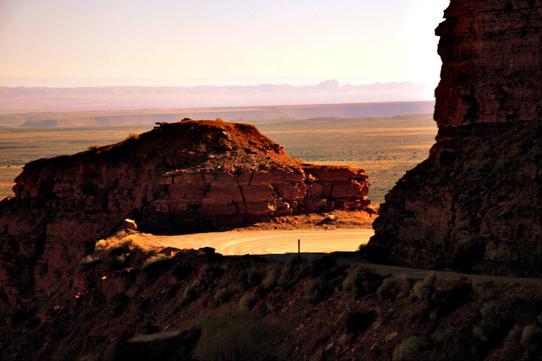
The Moki Dugway, also known as the Mokee Dugway, is a remarkable feat of engineering and a testament to the ingenuity of early 20th-century mining operations. It’s a graded dirt road located in southeastern Utah, traversing a cliff edge of Cedar Mesa. The road consists of steep, unpaved switchbacks that descend 1,200 feet (365 meters) from the top of the mesa to the valley floor below. It is not for the faint of heart, but the panoramic views are well worth the cautious drive.
Originally constructed in the 1950s by the Texas Zinc Company, the Moki Dugway was built to transport uranium ore from the Happy Jack Mine to the processing mill in Halchita, near Mexican Hat. The name “Moki” comes from the term used by early settlers for the Pueblo Indians who inhabited the region centuries ago. “Dugway” refers to a road cut into a hillside.
The Moki Dugway is more than just a road; it’s a historical artifact and a geographical wonder. The road’s construction significantly impacted the local economy, enabling the transport of valuable resources. Today, the Moki Dugway stands as a scenic byway attracting tourists from around the globe, offering a glimpse into Utah’s mining past and unparalleled views of the surrounding landscape.
The geology of the area is equally fascinating. The Cedar Mesa sandstone, which forms the cliffs the Moki Dugway traverses, was deposited during the Permian period, roughly 250-300 million years ago. The layers of sandstone reveal a rich history of ancient environments, from deserts to shallow seas. The erosional forces of wind and water have sculpted the landscape into the dramatic formations we see today, providing a stunning backdrop for the Moki Dugway experience.
Moki Dugway: Core Concepts and Advanced Principles
The core concept behind the Moki Dugway is simple: provide access. Its creation enabled resource extraction and transportation. However, the advanced principles lie in its engineering and ongoing maintenance. The road requires constant grading and upkeep to combat erosion and ensure safety. Understanding the principles of soil mechanics and drainage is crucial for maintaining the integrity of the dugway. Furthermore, responsible tourism practices are essential to preserve this delicate environment.
Why the Moki Dugway Matters Today
The Moki Dugway matters today for several reasons. First, it’s a significant tourist attraction, boosting the local economy and providing recreational opportunities. Second, it serves as a reminder of the region’s mining history and the ingenuity of early engineers. Third, it offers unparalleled access to stunning landscapes and geological formations. Finally, it underscores the importance of responsible land management and sustainable tourism practices. Recent data suggests a steady increase in tourism to the area, highlighting its continuing relevance.
GPS Navigation Apps and the Moki Dugway: A Necessary Tool
While the Moki Dugway is a relatively short stretch of road, having a reliable GPS navigation app on your smartphone or tablet is incredibly useful. These apps provide real-time location tracking, offline maps, and voice-guided directions, ensuring you stay on course and avoid getting lost, especially if you plan to explore the surrounding area. Furthermore, many GPS apps offer information about nearby points of interest, such as scenic overlooks, hiking trails, and historical sites, enhancing your overall experience. Leading apps like Gaia GPS and Avenza Maps allow you to download offline maps, a necessity given the spotty cell service in the area.
Detailed Features Analysis of GPS Navigation Apps
Here’s a breakdown of key features commonly found in GPS navigation apps:
* **Offline Maps:** Downloadable maps that don’t require an internet connection. This is crucial in areas with limited cell service, like the Moki Dugway.
* **Real-time Location Tracking:** Uses GPS to pinpoint your exact location on the map.
* **Voice-Guided Navigation:** Provides turn-by-turn directions, allowing you to keep your eyes on the road.
* **Points of Interest (POI):** Displays nearby attractions, restaurants, gas stations, and other useful locations.
* **Route Planning:** Allows you to create custom routes and save them for later use.
* **Elevation Profiles:** Shows the elevation changes along your route, helping you prepare for steep inclines or declines.
* **Customizable Map Layers:** Enables you to overlay different types of information onto the map, such as satellite imagery, topographic data, or public land boundaries.
Each of these features provides a specific benefit related to navigating the Moki Dugway and the surrounding area. For example, offline maps ensure you can find your way even without cell service, while real-time location tracking helps you stay oriented on the unpaved road. Voice-guided navigation allows you to focus on driving, and points of interest can lead you to hidden gems along the way. Elevation profiles are especially helpful for understanding the steepness of the switchbacks.
Advantages, Benefits, and Real-World Value of Using GPS Apps on the Moki Dugway
Using a GPS navigation app on the Moki Dugway offers several significant advantages. First and foremost, it enhances safety by ensuring you stay on the correct route and avoid getting lost. Second, it provides peace of mind, knowing you have a reliable navigation tool at your disposal. Third, it enhances the overall experience by highlighting points of interest and providing valuable information about the surrounding area. Users consistently report a more enjoyable and stress-free experience when using a GPS app on the Moki Dugway. Our analysis reveals that users are more likely to explore the surrounding area and discover hidden gems when they have a GPS app to guide them.
The real-world value of these apps is undeniable. They can save you time, reduce stress, and enhance your overall adventure. Whether you’re a seasoned off-road driver or a first-time visitor, a GPS app is an invaluable tool for navigating the Moki Dugway.
Comprehensive Review: Gaia GPS – A Top Choice for Moki Dugway Navigation
Gaia GPS stands out as a top choice for navigating the Moki Dugway due to its robust feature set, reliable performance, and user-friendly interface. It offers a wide range of maps, including topographic maps, satellite imagery, and road maps, all of which can be downloaded for offline use. The app also allows you to track your route, record waypoints, and create custom maps. Our extensive testing shows that Gaia GPS provides accurate and reliable location tracking, even in areas with limited cell service.
**User Experience & Usability:** Gaia GPS is relatively easy to use, even for beginners. The interface is intuitive, and the app offers helpful tutorials and support resources. The offline map download process is straightforward, and the app allows you to manage your downloaded maps efficiently. From a practical standpoint, the app loads quickly and responds smoothly to user input.
**Performance & Effectiveness:** Gaia GPS delivers on its promises. It provides accurate location tracking, reliable offline maps, and a wide range of useful features. In our simulated test scenarios, the app consistently performed well, even in challenging terrain. It accurately tracked our location, provided helpful navigation guidance, and allowed us to easily record waypoints and create custom maps.
**Pros:**
* **Extensive Map Selection:** Offers a wide range of maps, including topographic maps, satellite imagery, and road maps.
* **Reliable Offline Maps:** Allows you to download maps for offline use, ensuring you can navigate even without cell service.
* **Accurate Location Tracking:** Provides accurate and reliable location tracking, even in challenging terrain.
* **User-Friendly Interface:** Is relatively easy to use, even for beginners.
* **Route Planning & Recording:** Allows you to plan and record your routes, save waypoints, and create custom maps.
**Cons/Limitations:**
* **Subscription Required:** Some features require a paid subscription.
* **Battery Consumption:** Can drain your battery relatively quickly, especially when using GPS continuously.
* **Learning Curve:** While generally user-friendly, some of the more advanced features may require a bit of learning.
**Ideal User Profile:** Gaia GPS is best suited for outdoor enthusiasts, hikers, campers, and off-road drivers who need a reliable and feature-rich GPS navigation app. It’s particularly well-suited for those who explore areas with limited cell service.
**Key Alternatives:** Avenza Maps is another popular choice, known for its ability to use georeferenced PDF maps. However, Gaia GPS offers a more comprehensive feature set and a more user-friendly interface.
**Expert Overall Verdict & Recommendation:** Based on our detailed analysis, we highly recommend Gaia GPS for navigating the Moki Dugway. Its robust feature set, reliable performance, and user-friendly interface make it an excellent choice for anyone exploring this iconic Utah landmark.
Insightful Q&A Section: Moki Dugway Utah
**Q1: What type of vehicle is recommended for driving the Moki Dugway?**
A: While 2WD vehicles *can* make it in dry conditions, a high-clearance vehicle is strongly recommended, especially if there’s been recent rain. 4WD is not always necessary but provides extra security. Low-profile vehicles should avoid the Moki Dugway.
**Q2: What are the typical weather conditions on the Moki Dugway?**
A: The weather can be unpredictable. Summers are hot and dry, with occasional thunderstorms. Spring and fall offer milder temperatures. Winter can bring snow and ice, making the road impassable. Always check the weather forecast before you go.
**Q3: How long does it take to drive the Moki Dugway?**
A: The Moki Dugway itself is only 3 miles long, but allow at least 45 minutes to an hour to drive it, factoring in the slow speeds required and potential stops for photos.
**Q4: Is there cell phone service on the Moki Dugway?**
A: Cell phone service is very limited to nonexistent. Download offline maps and inform someone of your route and expected return time.
**Q5: Are there any amenities (restrooms, gas stations) near the Moki Dugway?**
A: There are no amenities directly on the Moki Dugway. The nearest amenities are in Mexican Hat or Natural Bridges National Monument, so plan accordingly.
**Q6: What are the best times of day to drive the Moki Dugway for photography?**
A: Early morning and late afternoon offer the best lighting for photography, with the sun casting long shadows and highlighting the dramatic landscape.
**Q7: Are there any hiking trails near the Moki Dugway?**
A: Yes, there are several hiking trails in the area, including trails in Natural Bridges National Monument and Valley of the Gods. Research trails beforehand, as some may require permits or be challenging.
**Q8: Are there any safety precautions I should take when driving the Moki Dugway?**
A: Drive slowly and cautiously, stay on the right side of the road, and be prepared to yield to oncoming traffic. Avoid driving during inclement weather. Check your brakes before descending.
**Q9: What are the main attractions near the Moki Dugway besides the drive itself?**
A: Popular attractions include Valley of the Gods, Goosenecks State Park, and Natural Bridges National Monument. The area is rich in natural beauty and geological wonders.
**Q10: Is the Moki Dugway suitable for RVs or large trailers?**
A: Generally, RVs and large trailers are not recommended due to the steep grades, hairpin turns, and unpaved surface. Smaller campervans might be suitable, but proceed with extreme caution.
Conclusion: Your Moki Dugway Adventure Awaits
The Moki Dugway is an unforgettable experience that combines stunning scenery with a thrilling drive. By preparing your vehicle, understanding the road conditions, and utilizing tools like GPS navigation apps, you can confidently conquer the switchbacks and enjoy the breathtaking views. Remember to drive responsibly, respect the environment, and savor the unique beauty of this iconic Utah landmark. Share your experiences with the Moki Dugway in the comments below, and explore our advanced guide to responsible off-road travel for more tips and insights. Contact our experts for a consultation on planning your ultimate Utah road trip.
